UPDATE: Severe weather threatens Seattle and Western Washington this week as authorities confirm renewed flooding risks across multiple rivers. Flood Warnings remain in effect for the Skagit, White, Green, Cedar, Chehalis, Snohomish, and Cowlitz Rivers, with many areas still grappling with prior flooding impacts.
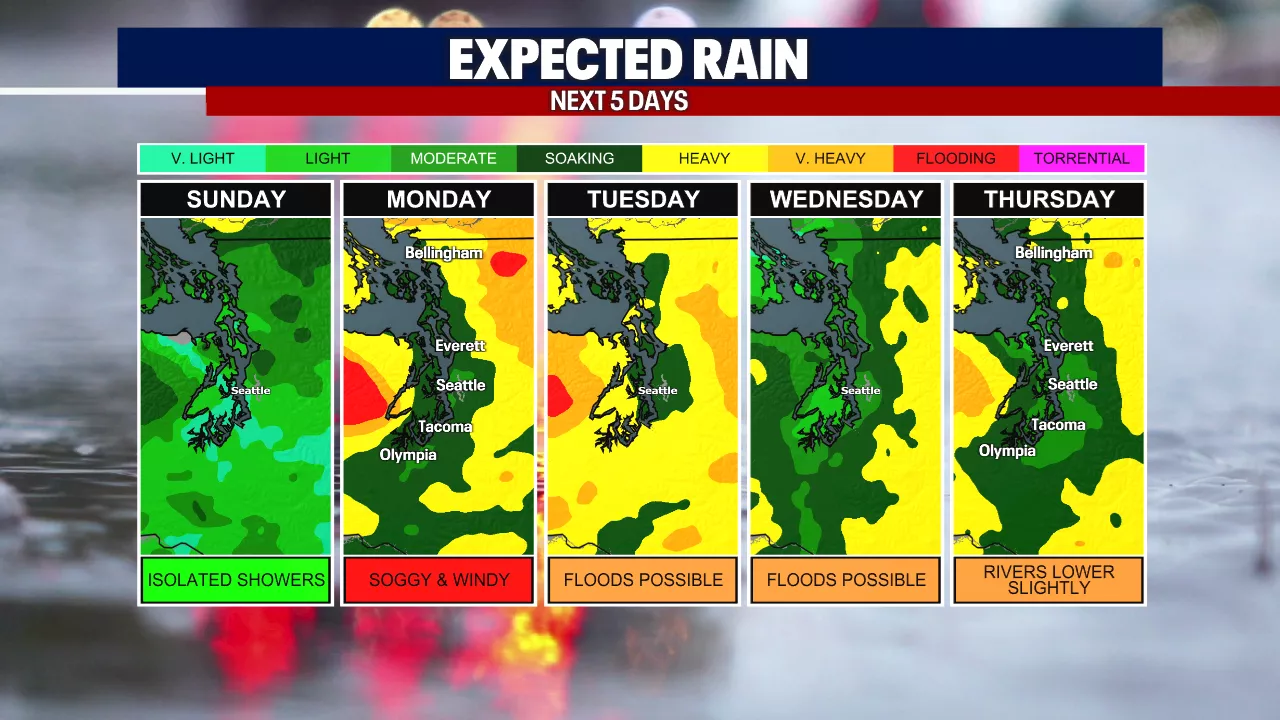
As of 12 p.m. Sunday, roads in affected regions are closed, and communities are bracing for another round of rain and wind. The National Weather Service warns of significant flooding risks, particularly in Auburn, where the White River is expected to inundate low-lying areas.
IMPACTS:
According to the NWS, “The White River will flood areas above and below Mud Mountain Dam downstream to near Auburn.” Residents in the Red Creek area may find access to their homes cut off due to swift floodwaters.
For the Green River near Auburn, minor flooding is forecasted, with water potentially covering SE Green Valley Rd. Residents are advised to remain vigilant as river levels approach critical thresholds, particularly during the next atmospheric river event dubbed a Pineapple Express. This system is characterized by moisture extending from Hawaii, resulting in warmer, wetter conditions.
The rain is projected to peak on Monday, with gusts exceeding 40 mph across the Seattle area. A Wind Advisory is in effect from 10 p.m. tonight to 10 p.m. Monday, raising concerns about falling trees in saturated soil conditions. Residents are urged to limit outdoor activities to reduce injury risks.
Fortunately, cooler air is expected to arrive by late Tuesday, likely converting rain to snow in the mountains and reducing runoff into local rivers. However, this could complicate travel as snow impacts mountain passes starting Wednesday morning.
Authorities report that both the Skagit and Snoqualmie Rivers are at risk of major flooding again by Tuesday night or Wednesday morning. While current water levels are not as high as those seen last week, flood control systems will again be tested, raising alarms in vulnerable communities.
The risk of landslides remains elevated across Western Washington, particularly in steep coastal bluffs and recently burned areas. The potential for debris flows adds another layer of danger to an already precarious situation.
Meteorologist Abby Acone emphasizes the importance of staying informed: “Take good care and prepare for the worst as we navigate this challenging weather pattern.”
Stay tuned for ongoing updates as conditions evolve. For the latest local news and weather alerts, download the FOX LOCAL app available on the Apple App Store and Google Play Store.