Strong to Severe Storms Develop Tonight Along I-20 Corridor
Strong storms are moving in tonight across the southern United States with a low but present threat of severe weather, including large hail and damaging winds. The cold front is drifting slowly south, while an upper-level disturbance pushes from west to east along the front, triggering waves of showers and thunderstorms mainly along and south of Interstate 20.
The CBS 42 Weather Livestream Channel has issued a Marginal Risk (Level 1/5) for severe weather, emphasizing that while the risk remains low, residents in affected areas should stay alert to fast-changing conditions. Overnight lows will fall into the lower to mid-50s, providing a cool backdrop to the storm activity.
Heavy Rainfall Signals Drought Relief but Raises Flood Concerns
Many locations are expected to receive 2 to 3 inches of rain by the time this round ends, which will bring some relief to the persistent drought impacting parts of the Southeast. However, rapid rainfall amounts could lead to localized flooding risks, especially in urban and low-lying areas. Residents should monitor local advisories closely.
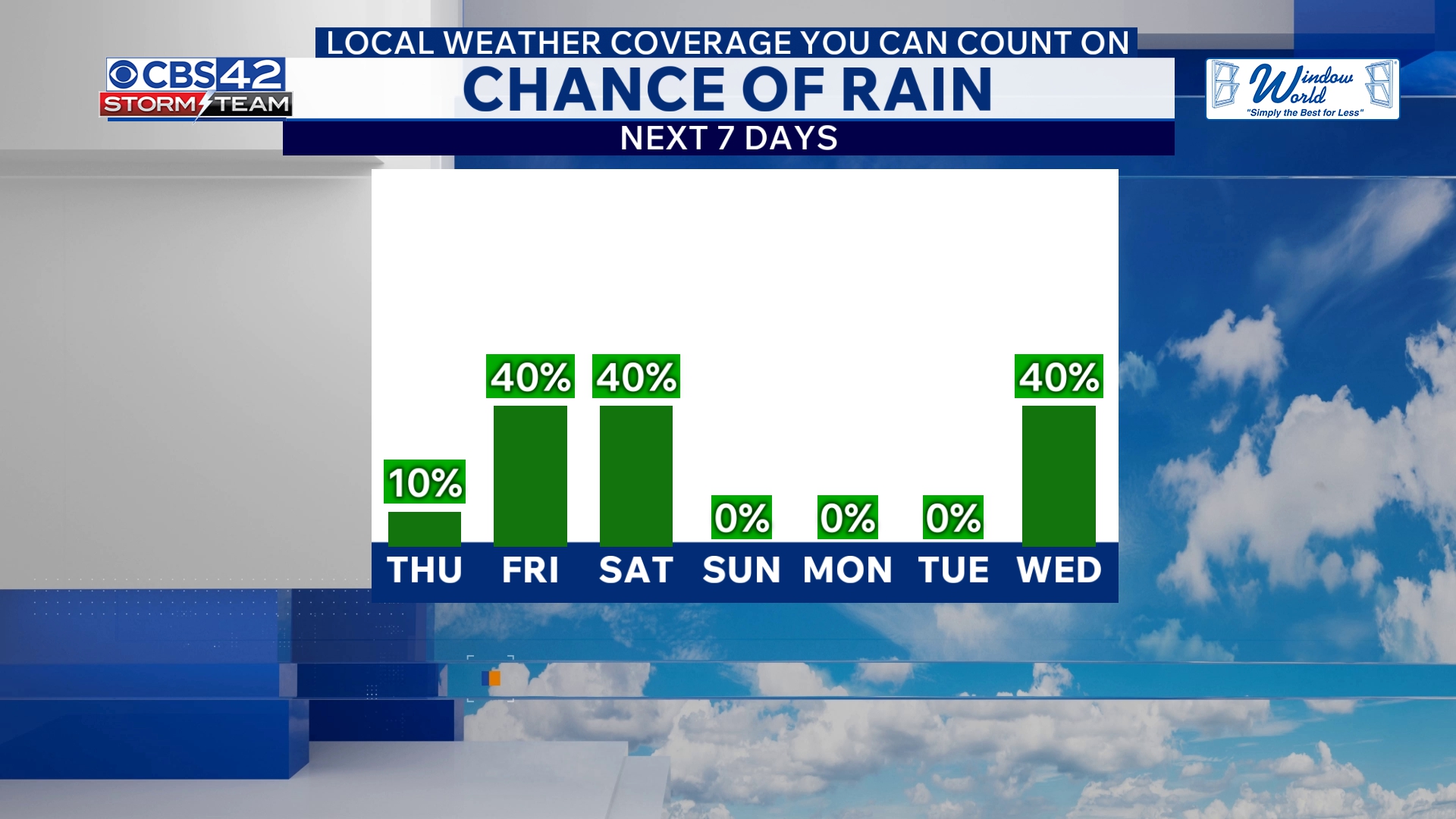
After tonight, rain will taper off by morning as the cold front pushes further south toward the Gulf Coast. Thursday will bring a welcome break with drier conditions and a partly cloudy sky, while temperatures cool to highs in the mid-70s.
More Rain and Cool Weather Arrive Friday Through Saturday Morning
The unsettled pattern continues on Friday as an area of low pressure tracks along a stalled coastal boundary, unleashing scattered showers and a few non-severe thunderstorms through the day. Cooler air will dominate, with highs dipping to the upper 60s. The storm activity will intensify on Friday night into Saturday morning, producing another widespread round of rain and storms that could disrupt weekend plans.
Temperatures will drop to the upper 40s to around 50 overnight, setting up a chilly start for Saturday. Showers may linger into the morning before skies gradually clear in the afternoon with highs remaining in the upper 60s. Saturday evening will turn mostly clear and colder, with lows dipping into the 40s.
Weekend Outlook Brings Dry Weather and Sunshine on Sunday
Sunday looks to be a bright day with plenty of sunshine and dry conditions across the Southeast, as high pressure builds in behind the departing low-pressure system. Temperatures are expected to rise back to the upper 60s, offering a pleasant end to the weekend after several days of stormy weather.
Why This Matters Now
For millions of Americans across the Southeast, tonight’s storms and Friday’s wet weather are significant because they mark the first substantial rainfall in weeks, potentially easing drought strains on agriculture and water supplies. However, the severe weather threat, while low, means residents should keep weather apps and warnings on standby to avoid surprises.
The CBS 42 Weather Livestream Channel continues to monitor the evolving storm system and advises the public to stay tuned for the latest updates.
What To Watch For Next
As the storm system moves eastward, Delaware and other Mid-Atlantic states should watch for any impacts or secondary systems in the coming days, especially as coastal and stalled boundaries often shift quickly. While the major threat zones are south of Delaware, remnants could bring cooler temperatures and scattered showers locally later this weekend.
Stay with The Delaware Herald for breaking weather updates and detailed forecasts throughout this urgent weather event.